
File:Vietnam relief location map.jpg

本预览个尺寸:306×599像素。 其他分辨率:122×240像素 | 245×480像素 | 392×768像素 | 1,200×2,349像素。
原始文件 (1,200×2,349像素,文件大小:1.68 MB,MIME类型:image/jpeg)
小结
| 描述 |
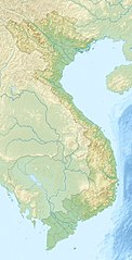
English: Location map of Vietnam.
Equirectangular projection. Strechted by 104.0%. Geographic limits of the map: * N: 24.0° N * S: 8.0° N * W: 101.8° E * E: 110.3° EMade with Natural Earth. Free vector and raster map data @ naturalearthdata.com. |
| 日脚 | |
| 来源 | 自家个作品 |
| 作者 | Uwe Dedering |
| 其他版本 |
Derivative works of this file:
|

授权协议
我,本作品著作权人,特此采用以下许可协议发表本作品:
本文件用知识共享“署名-相同方式共享 3.0 未本地化版本”许可协议授权。
- 侬可以自由地:
- 分享 – 复制、发行、展览、表演、放映、广播或通过信息网络传播本作品
- 修改 – 改编本作品
- 来箇眼条件下底:
- 署名 – 侬板定要畀出适当个署名,提供许可协议个链接,同时标明侬阿有改动过。侬好用任何合理个方式来做,但必过弗好用任何方式暗示许可人是侬或侬个使用背书。
- 相同方式共享 – 如果你混合、转换或基于此素材创作,你板定要用搭原来相同或兼容个许可协议分发你个贡献作品。

|
已授权复制、传播搭/或修改本文档,依据自由软件基金会发布个GNU自由文档许可证1.2版或任何后续版本个条款;呒不弗可变章节,也呒不封面封底文字。许可证个副本包括勒GNU Free Documentation License章节当中。 |
侬好选择侬需要个许可协议。
文件历史
揿一个日脚/辰光来望当时出现过个文件。
| 日脚 / 辰光 | 微缩图 | 维度 | 用户 | 备注 | |
|---|---|---|---|---|---|
| 当前 | 2010年4月24号 (六) 18:30 | | 1,200 × 2,349(1.68 MB) | Uwe Dedering | {{Information |Description={{en|1=Location map of Vietnam. Equirectangular projection. Strechted by 104.0%. Geographic limits of the map: * N: 24.0° N * S: 8.0° N * W: 101.8° E * E: 110.3° E Made with Natural Earth. Free vector and raster map da |
文件用法
呒一页用着箇文件。
全域文件用场
下底个其他wiki使用箇只文件:
- als.wikipedia.org上个用途
- am.wikipedia.org上个用途
- ar.wikipedia.org上个用途
- ast.wikipedia.org上个用途
- az.wikipedia.org上个用途
- ban.wikipedia.org上个用途
- ba.wikipedia.org上个用途
- bcl.wikipedia.org上个用途
- be.wikipedia.org上个用途
- bg.wikipedia.org上个用途
查看本文件个更多全域用途。