
File:Tristan Map.png

本预览个尺寸:685×600像素。 其他分辨率:274×240像素 | 548×480像素 | 877×768像素 | 1,169×1,024像素 | 2,338×2,048像素 | 2,787×2,441像素。
原始文件 (2,787×2,441像素,文件大小:639 KB,MIME类型:image/png)
小结
| 描述 |
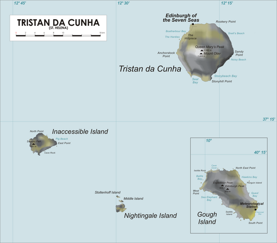
Map of Tristan da Cunha Group, Southern Atlantic Ocean
|
| 日脚 | 2006年4月19日 (原始上传日期) |
| 来源 | No machine-readable source provided. Own work assumed (based on copyright claims). |
| 作者 | No machine-readable author provided. Varp~commonswiki assumed (based on copyright claims). |
| 其他版本 |
.png)
授权协议
| 我,本作品著作权人,释出本作品至公有领域。这适用于全世界。 在一些国家这可能不合法;如果是这样的话,那么: 我无条件地授予任何人以任何目的使用本作品的权利,除非这些条件是法律规定所必需的。 |
文件历史
揿一个日脚/辰光来望当时出现过个文件。
| 日脚 / 辰光 | 微缩图 | 维度 | 用户 | 备注 | |
|---|---|---|---|---|---|
| 当前 | 2020年4月10号 (五) 07:19 | | 2,787 × 2,441(639 KB) | Getsnoopy | Fixed formatting for DMS grid lines labels as per SI. |
| 2017年3月24号 (五) 02:55 |  | 2,787 × 2,441(578 KB) | Jeanjung212 | Lossless Compressed/optimized png decreasing file size by 237453 bytes | |
| 2009年4月6号 (一) 04:38 |  | 2,787 × 2,441(810 KB) | Mahahahaneapneap | Compressed | |
| 2006年4月22号 (六) 19:43 |  | 2,787 × 2,441(853 KB) | Varp~commonswiki | ||
| 2006年4月20号 (四) 02:28 |  | 2,542 × 2,441(555 KB) | Varp~commonswiki | *Map of Tristan da Cunha Group, Southern Atlantic Ocean *drawn by varp |
文件用法
下向许5张用着箇文件:
全域文件用场
下底个其他wiki使用箇只文件:
- af.wikipedia.org上个用途
- ang.wikipedia.org上个用途
- an.wikipedia.org上个用途
- ar.wikipedia.org上个用途
- ast.wikipedia.org上个用途
- az.wikipedia.org上个用途
- bg.wikipedia.org上个用途
- bn.wikipedia.org上个用途
- br.wikipedia.org上个用途
- bs.wikipedia.org上个用途
- ca.wikipedia.org上个用途
- ceb.wikipedia.org上个用途
- cs.wikipedia.org上个用途
- cy.wikipedia.org上个用途
- da.wikipedia.org上个用途
- de.wikipedia.org上个用途
- de.wikivoyage.org上个用途
- el.wikipedia.org上个用途
- en.wikipedia.org上个用途
查看本文件个更多全域用途。