
File:Take Ichi convoy.jpg
原始文件 (740×906像素,文件大小:93 KB,MIME类型:image/jpeg)

|
此map图片可使用矢量图形重新创建为SVG文件。这具有很多好处;更多信息请参见共享资源:待清理媒体。如果存在此图片的SVG格式,请将其上传,然后将此模板替换为
{{vector version available|新图片名称}}。
建议您将SVG命名为“Take Ichi convoy.svg”,这样在使用Vector version available(或Vva)模板时就不需要填写新图片名称参数。 |


小结
| 描述 |
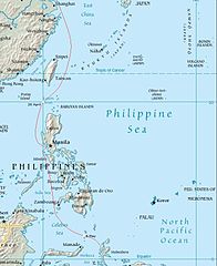
English: Map showing the route of the Japanese Take Ichi convoy and the location of the United States submarine attacks on the convoy. |
| 日脚 | (UTC) |
| 来源 |
个人作品,使用:
|
| 作者 |
Central Intelligence Agency |
| 这是一张修改过的图片,这意味着它已在原版本的基础上通过软件进行了编辑,改动内容:Convoy route added。其原始版本为:Southeast asia.jpg。修改者: Nick-D。
|
|
|
 |
原始上传日志
This image is a derivative work of the following images:
- File:Southeast_asia.jpg licensed with PD-USGov-CIA-WF
Uploaded with derivativeFX
文件历史
揿一个日脚/辰光来望当时出现过个文件。
| 日脚 / 辰光 | 微缩图 | 维度 | 用户 | 备注 | |
|---|---|---|---|---|---|
| 当前 | 2009年3月17号 (两) 15:53 |  | 740 × 906(93 KB) | Nick-D | {{Information |Description=May showing the route of the Japanese Take Ichi convoy and the location of the United States submarine attacks on the convoy. Convoy route is from Parillo, Mark P. (1993). ''The Japanese Merchant Marine in World War II''. Annapo |
文件用法
下向许1张用着箇文件:
全域文件用场
下底个其他wiki使用箇只文件:
- br.wikipedia.org上个用途
- de.wikipedia.org上个用途
- en.wikipedia.org上个用途
- fr.wikipedia.org上个用途
- id.wikipedia.org上个用途
- ja.wikipedia.org上个用途
- pl.wikipedia.org上个用途
- ru.wikipedia.org上个用途
- www.wikidata.org上个用途
- zh.wikipedia.org上个用途