
File:Philippines location map.svg

此SVG文件的PNG预览的大小:454×599像素。 其他分辨率:182×240像素 | 364×480像素 | 582×768像素 | 776×1,024像素 | 1,552×2,048像素 | 1,871×2,468像素。
原始文件 (SVG文件,名义大小:1,871×2,468像素,文件大小:2.18 MB)
小结
| 描述 |
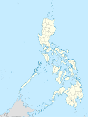
Deutsch: Positionskarte der Philippinen
Quadratische Plattkarte, N-S-Streckung 103 %. Geographische Begrenzung der Karte:
English: Location map of the Philippines
Equirectangular projection, N/S stretching 103 %. Geographic limits of the map:
|
| 日脚 | |
| 来源 |
own work, using
|
| 作者 | NordNordWest |
| 其他版本 |
|


|
|
授权协议
我,本作品著作权人,特此采用以下许可协议发表本作品:

|
已授权复制、传播搭/或修改本文档,依据自由软件基金会发布个GNU自由文档许可证1.2版或任何后续版本个条款;呒不弗可变章节,也呒不封面封底文字。许可证个副本包括勒GNU Free Documentation License章节当中。 |
本文件采用知识共享署名 3.0 未本地化版本许可协议授权。
- 侬可以自由地:
- 分享 – 复制、发行、展览、表演、放映、广播或通过信息网络传播本作品
- 修改 – 改编本作品
- 来箇眼条件下底:
- 署名 – 侬板定要畀出适当个署名,提供许可协议个链接,同时标明侬阿有改动过。侬好用任何合理个方式来做,但必过弗好用任何方式暗示许可人是侬或侬个使用背书。
侬好选择侬需要个许可协议。
文件历史
揿一个日脚/辰光来望当时出现过个文件。
| 日脚 / 辰光 | 微缩图 | 维度 | 用户 | 备注 | |
|---|---|---|---|---|---|
| 当前 | 2016年3月26号 (六) 06:17 | | 1,871 × 2,468(2.18 MB) | Man77 | upd NIR, Davao |
| 2013年10月14号 (一) 19:46 |  | 1,871 × 2,468(2.2 MB) | Hariboneagle927 | fix | |
| 2013年10月14号 (一) 19:07 |  | 1,871 × 2,468(2.15 MB) | Hariboneagle927 | fix. Cagayan | |
| 2013年10月14号 (一) 18:58 |  | 1,871 × 2,468(2.15 MB) | Hariboneagle927 | Made some update and corrected some minor errors. | |
| 2013年10月9号 (三) 15:22 |  | 1,871 × 2,468(2.14 MB) | Hellerick | Regrouped for easier recoloring. | |
| 2013年8月7号 (三) 14:13 |  | 1,871 × 2,468(1.07 MB) | Hellerick | Regional division replaced with provincial division. | |
| 2009年7月6号 (一) 03:09 |  | 1,871 × 2,468(1,009 KB) | NordNordWest | ||
| 2009年5月26号 (两) 05:04 |  | 1,687 × 2,469(999 KB) | NordNordWest | {{Information |Description= {{de|Positionskarte der Philippinen}} Quadratische Plattkarte, N-S-Streckung 103 %. Geographische Begrenzung der Karte: * N: 21.2° N * S: 4.3° N * W: 115.4° O * O: 127.3° O {{en|Location map of the [[:en |
文件用法
呒一页用着箇文件。
全域文件用场
下底个其他wiki使用箇只文件:
- af.wikipedia.org上个用途
- als.wikipedia.org上个用途
- an.wikipedia.org上个用途
- az.wikipedia.org上个用途
- be-tarask.wikipedia.org上个用途
- be.wikipedia.org上个用途
- bn.wikipedia.org上个用途
- ce.wikipedia.org上个用途
- ckb.wikipedia.org上个用途
- crh.wikipedia.org上个用途
- cs.wikipedia.org上个用途
查看本文件个更多全域用途。