
File:Falkland Islands map.svg

此SVG文件的PNG预览的大小:769×600像素。 其他分辨率:308×240像素 | 616×480像素 | 985×768像素 | 1,280×998像素 | 2,560×1,996像素 | 1,090×850像素。
原始文件 (SVG文件,名义大小:1,090×850像素,文件大小:583 KB)

|
本文件已被Falkland Islands topographic map-en.svg取代。建议您使用其他文件。请注意,删除被取代的图片需要达成一致。 使用其他文件的理由:“More precise map; created from NASA's digital elevation model”
|

|
小结
| 描述 |
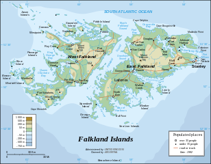
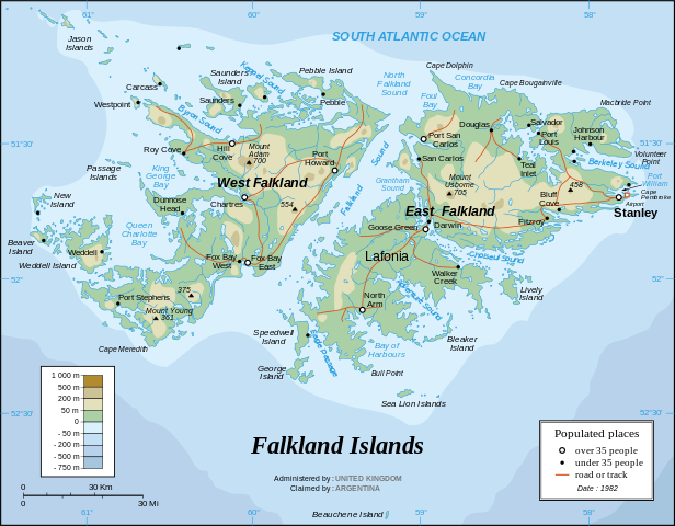
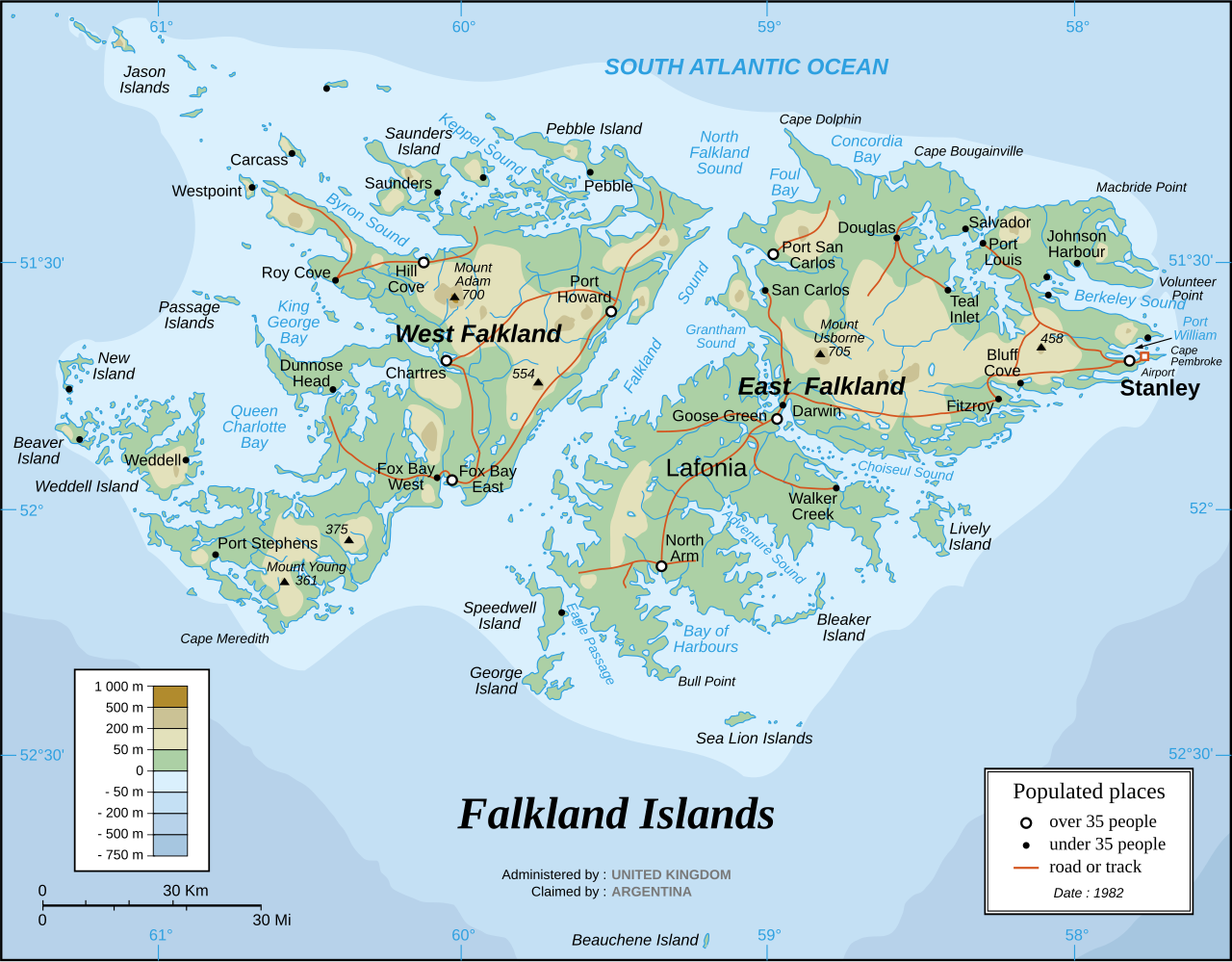
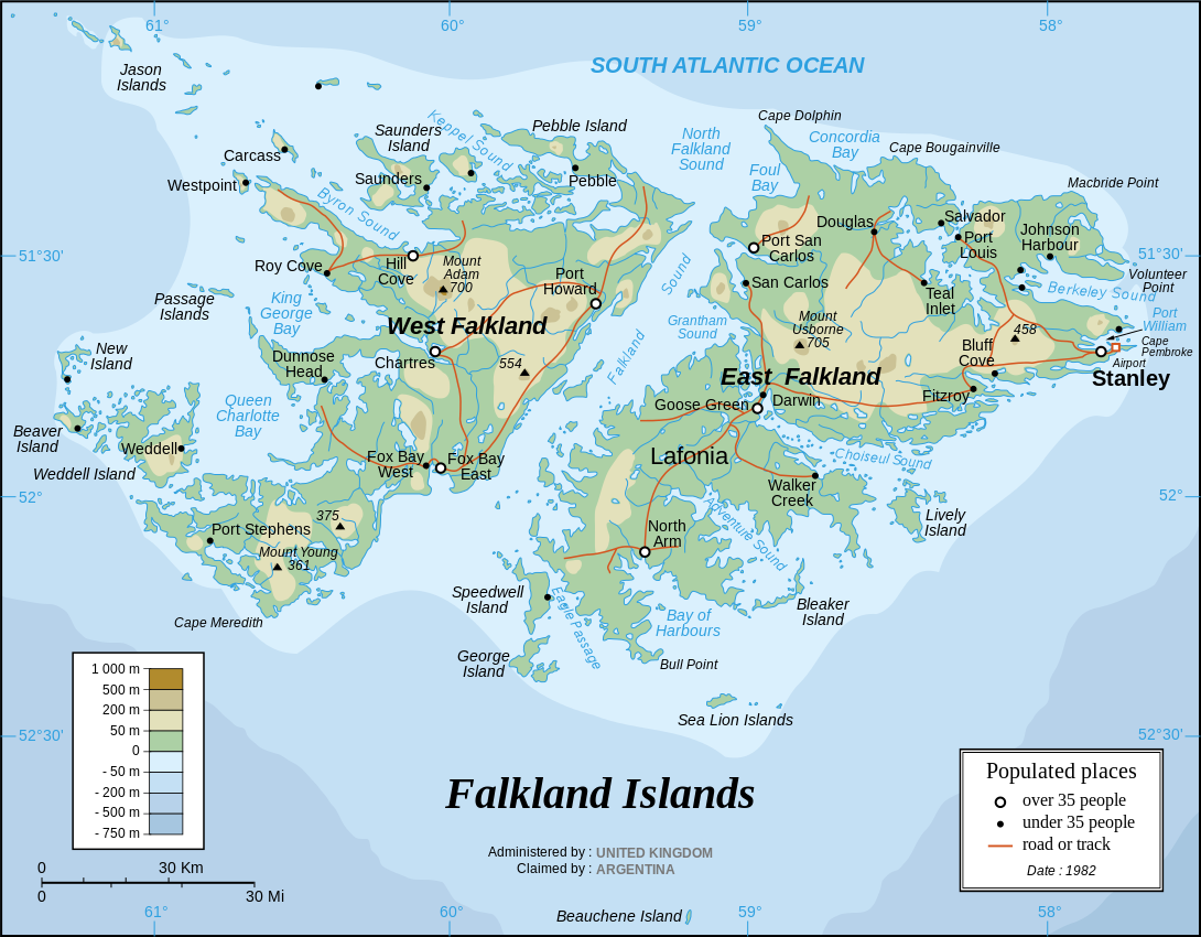
English: The Falkland Islands are an archipelago in the South Atlantic Ocean, located 300 miles off the coast of Argentina. They consist of two main islands, East Falkland and West Falkland, together with about 700 smaller islands. Stanley, on East Falkland, is the capital and largest city. The islands are a self-governing Overseas Territory of the United Kingdom, but have been the subject of a claim to sovereignty by Argentina since the British invasion of 1833.
Français : Carte en anglais des îles Malouines |
| 日脚 | |
| 来源 |
Own work Background and elevation reference maps : Microsoft Encarta atlas (1999 edition) and UK government map 1982 demographic data : CIA map available on the site of the University of Texas at Austin |
| 作者 | Eric Gaba (Sting) |
| 其他版本 | in French: Iles Malouines carte.svg |
| SVG开发 |
Français :
- Sujet : Carte en anglais des îles Malouines ;
- Sources : Création personnelle
- Fond de carte et relief basés sur : atlas Encarta de Microsoft (édition 1999) et carte du gouvernement britannique ;
- Données démographiques de 1982 : carte de la CIA disponible sur la site de l'Université du Texas à Austin ;
- Auteur : Eric Gaba (fr:Sting) ;
- Date : Septembre 2006.
- Autre version : francophone : Image:Iles_Malouines_carte.svg
授权协议
我,本作品著作权人,特此采用以下许可协议发表本作品:
本文件采用知识共享署名-相同方式共享 2.5 通用许可协议授权。
- 侬可以自由地:
- 分享 – 复制、发行、展览、表演、放映、广播或通过信息网络传播本作品
- 修改 – 改编本作品
- 来箇眼条件下底:
- 署名 – 侬板定要畀出适当个署名,提供许可协议个链接,同时标明侬阿有改动过。侬好用任何合理个方式来做,但必过弗好用任何方式暗示许可人是侬或侬个使用背书。
- 相同方式共享 – 如果你混合、转换或基于此素材创作,你板定要用搭原来相同或兼容个许可协议分发你个贡献作品。
文件历史
揿一个日脚/辰光来望当时出现过个文件。
| 日脚 / 辰光 | 微缩图 | 维度 | 用户 | 备注 | |
|---|---|---|---|---|---|
| 当前 | 2007年4月1号 (日) 04:06 | | 1,090 × 850(583 KB) | Sting | Some text corrections |
| 2006年9月28号 (四) 10:58 |  | 1,090 × 850(586 KB) | Sting | Cosmetic correction | |
| 2006年9月28号 (四) 10:48 |  | 1,090 × 850(586 KB) | Sting | {{Information |Description=Map of the Falkland Islands |Source=1982 demographic data : [http://www.lib.utexas.edu/maps/americas/falkland_islands.gif CIA map] available on the site of the [http://www.lib.utexas.edu/maps/americas.html#F University of Texas |
文件用法
下向许1张用着箇文件:
全域文件用场
下底个其他wiki使用箇只文件:
- azb.wikipedia.org上个用途
- de.wikipedia.org上个用途
- en.wikipedia.org上个用途
- es.wikinews.org上个用途
- gd.wikipedia.org上个用途
- he.wikipedia.org上个用途
- it.wikipedia.org上个用途
- ja.wikipedia.org上个用途
- lt.wikipedia.org上个用途
- no.wikipedia.org上个用途
- ro.wikipedia.org上个用途
- sr.wikipedia.org上个用途