
File:Europe subregion map UN geoscheme.svg

此SVG文件的PNG预览的大小:680×520像素。 其他分辨率:314×240像素 | 628×480像素 | 1,004×768像素 | 1,280×979像素 | 2,560×1,958像素。
原始文件 (SVG文件,名义大小:680×520像素,文件大小:228 KB)
小结
| 描述 |
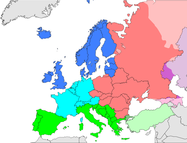
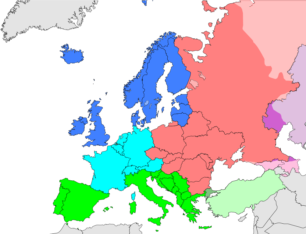
Deutsch: Subregionen Europas (nach UN Geoschema)
Nordeuropa
Westeuropa
Osteuropa
Südeuropa English: Subregions of Europe (UN geoscheme)
Northern Europe
Western Europe
Eastern Europe
Southern Europe
Countries of West Asia with partial territory in Southern Europe: Turkey
Countries of West Asia with partial territory in Eastern Europe: Georgia and Azerbaijan
Countries of Central Asia with partial territory in Eastern Europe: Kazakhstan
Русский: Макрорегионы Европы (классификация ООН)
Северная Европа
Западная Европа
Восточная Европа
Южная Европа
Страны макрорегиона Западная Азия с частичной территорией в Южной Европе: Турция
Страны макрорегиона Западная Азия с частичной территорией в Восточной Европе: Азербайджан и Грузия
Страны макрорегиона Центральная Азия с частичной территорией в Восточной Европе: Казахстан
Українська: Підрегіони Європи (класифікація Організації Об’єднаних Націй)
Північна Європа
Західна Європа
Східна Європа
Південна Європа |
| 日脚 | |
| 来源 | 自家个作品 |
| 作者 | Kolja21 |
| 其他版本 |
Derivative works of this file:
|


_de.png)
.png)


授权协议
我,本作品著作权人,特此采用以下许可协议发表本作品:
本文件采用知识共享署名 3.0 未本地化版本许可协议授权。
- 侬可以自由地:
- 分享 – 复制、发行、展览、表演、放映、广播或通过信息网络传播本作品
- 修改 – 改编本作品
- 来箇眼条件下底:
- 署名 – 侬板定要畀出适当个署名,提供许可协议个链接,同时标明侬阿有改动过。侬好用任何合理个方式来做,但必过弗好用任何方式暗示许可人是侬或侬个使用背书。
文件历史
揿一个日脚/辰光来望当时出现过个文件。
| 日脚 / 辰光 | 微缩图 | 维度 | 用户 | 备注 | |
|---|---|---|---|---|---|
| 当前 | 2021年11月9号 (两) 21:50 | | 680 × 520(228 KB) | TU-nor | Reverted to version as of 12:17, 22 February 2021 (UTC) No reason to color countries that are outside Europe in the Geosceme unless they are geographically transcontinental |
| 2021年8月6号 (五) 08:12 |  | 680 × 520(262 KB) | Vesperius | Cleanup at the edges. | |
| 2021年8月6号 (五) 07:53 |  | 680 × 520(238 KB) | Vesperius | Cyprus and Armenia included. | |
| 2021年2月22号 (一) 20:17 |  | 680 × 520(228 KB) | TU-nor | Andorra is Southern Europe in UN geoscheme | |
| 2015年9月23号 (三) 19:17 |  | 680 × 520(572 KB) | Alex Great | Reverted to version as of 09:22, 1 June 2014 | |
| 2015年7月10号 (五) 17:48 |  | 744 × 1,052(430 KB) | Andrej500 | Crimea | |
| 2014年6月1号 (日) 17:22 |  | 680 × 520(572 KB) | Insider | Russian Sochi Sector in Asia | |
| 2009年5月28号 (四) 02:50 |  | 680 × 520(571 KB) | Kolja21 | {{Information |Description={{en|1=Subregions of Europe (UN geoschme)}} {{de|1=Subregionen Europas (nach UN Geoschema)}} |Source=Eigenes Werk (own work) |Author=Kolja21 |Date=2009-05-23 |Permission= |other_ |
文件用法
下向许1张用着箇文件:
全域文件用场
下底个其他wiki使用箇只文件:
- af.wikipedia.org上个用途
- am.wikipedia.org上个用途
- ar.wikipedia.org上个用途
- av.wikipedia.org上个用途
- awa.wikipedia.org上个用途
- azb.wikipedia.org上个用途
- ba.wikipedia.org上个用途
- be.wikipedia.org上个用途
- bn.wikipedia.org上个用途
- br.wikipedia.org上个用途
- ce.wikipedia.org上个用途
- cs.wikipedia.org上个用途
- cv.wikipedia.org上个用途
- cy.wikipedia.org上个用途
- de.wikipedia.org上个用途
- diq.wikipedia.org上个用途
- el.wikipedia.org上个用途
- en.wikipedia.org上个用途
查看本文件个更多全域用途。