
File:Europe map 1648-es.png

本预览个尺寸:800×577像素。 其他分辨率:320×231像素 | 640×462像素 | 1,024×739像素 | 1,280×924像素 | 1,894×1,367像素。
原始文件 (1,894×1,367像素,文件大小:141 KB,MIME类型:image/png)
| 描述 |
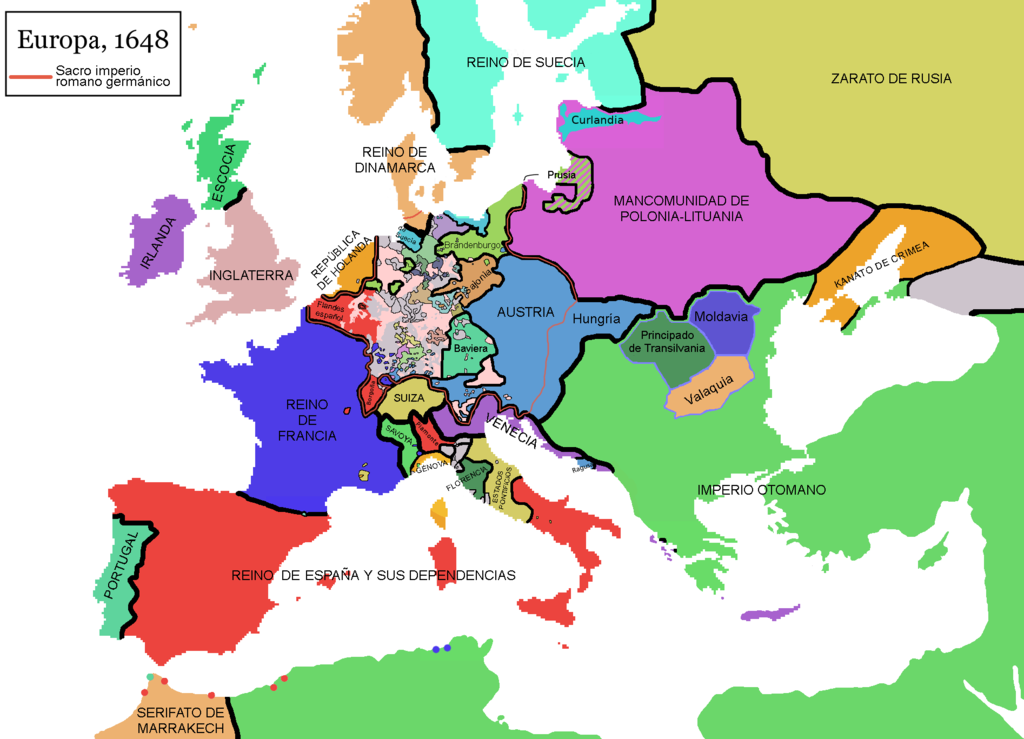
English: Map of Europe in 1648, at the end of the Thirty Years War. Red line marks the border of the Holy Roman Empire. (Labels in Spanish).
Español: Mapa de Europa en 1648, al final de la guerra de los treinta años. La línea roja marca las fronteras del Sacro imperio romano germánico.
Falta por cambiar el nombre de Piamonte, que es erroneo, la zona es el Milanesado o Ducado de Milan |
| 日脚 | (UTC) |
| 来源 | |
| 作者 |
|
| 这是一张修改过的图片,这意味着它已在原版本的基础上通过软件进行了编辑,改动内容:Rótulos en español (labels in Spanis) + Hungría。其原始版本为:Europe map 1648.PNG。修改者: Osado。
|
我,本作品著作权人,特此采用以下许可协议发表本作品:
| 本文件用知识共享“署名-相同方式共享 3.0 未本地化版本”许可协议授权。 | ||
| ||
| 本许可协议标签作为GFDL许可协议更新的组成部分被添加至本文件。 |

|
已授权复制、传播搭/或修改本文档,依据自由软件基金会发布个GNU自由文档许可证1.2版或任何后续版本个条款;呒不弗可变章节,也呒不封面封底文字。许可证个副本包括勒GNU Free Documentation License章节当中。 |
侬好选择侬需要个许可协议。
原始上传日志
This image is a derivative work of the following images:
- File:Europe_map_1648.PNG licensed with Cc-by-sa-3.0-migrated, GFDL
- 2010-09-25T11:40:35Z Fakirbakir 1894x1367 (197540 Bytes) Minor
- 2010-09-25T10:45:19Z Fakirbakir 1894x1367 (197532 Bytes) Transylvania Moldavia and Wallachia were a 'semi-independent' state under the suzerainty of the Ottoman Empire.
- 2008-12-12T02:13:45Z Mathiasrex 1894x1367 (197990 Bytes) In 1648 Duchy of Prussia was yet a fief of the Polish Crown
- 2008-11-04T22:12:11Z Beliar 1894x1367 (197454 Bytes) Holstein was part of the HRE but was ruled by the danish king in personal union as the duce of H.
- 2007-10-24T07:09:47Z Conscious 1894x1367 (186157 Bytes) "Tsardom of Russia" instead of "Russian Empire" (this is a pre-1721 map)
- 2007-01-10T05:47:14Z Roke 1894x1367 (186110 Bytes) more detail HRE, fixes
- 2006-06-08T00:10:58Z Roke 1894x1367 (186146 Bytes) change to polish-lithuanian commonwealth after comment on en
- 2006-05-09T09:08:45Z Roke 1894x1367 (184339 Bytes) cropped right version
- 2006-05-08T13:12:58Z Roke 1894x1374 (111881 Bytes) minor crop
- 2006-05-05T05:12:47Z Roke 1900x1378 (185935 Bytes) Map of Europe in 1648 (at the end of the [[w:Thirty Years War|Thirty Years War]], based on free map of europe [[:Image:BlankMap-Europe.png]] {{Europe}} [[Category:Historical maps of Europe]]
Uploaded with derivativeFX
文件历史
揿一个日脚/辰光来望当时出现过个文件。
| 日脚 / 辰光 | 微缩图 | 维度 | 用户 | 备注 | |
|---|---|---|---|---|---|
| 当前 | 2017年11月10号 (五) 19:48 | | 1,894 × 1,367(141 KB) | Raderich | Corregidos algunos errores en el mapa. |
| 2017年9月9号 (六) 23:52 |  | 1,894 × 1,367(134 KB) | Daniel Medina | Corregidas algunas erratas heredadas de la imagen original en inglés de 2010 en base a la versión de 2017 de la misma imagen (Media:Europe_map_1648.PNG. Concretamente se añaden: • la anexión de Cataluña por parte de Francia • enclaves f... | |
| 2013年5月3号 (五) 22:23 |  | 1,894 × 1,367(121 KB) | Osado | Label improvement; Burgundia → Borgoña | |
| 2013年5月3号 (五) 22:15 |  | 1,894 × 1,367(150 KB) | Osado | Reverted to version as of 11:31, 4 August 2011 | |
| 2013年5月2号 (四) 17:57 |  | 1,894 × 1,367(121 KB) | Osado | Label improvement; Burgundia → Borgoña | |
| 2011年8月4号 (四) 19:31 |  | 1,894 × 1,367(150 KB) | Osado | {{Information |Description={{en|Map of Europe in 1648, at the end of the Thirty Years War. Red line marks the border of the Holy Roman Empire. (Labels in Spanish).}} {{es|Mapa de Europa en 1648, al final de la guerra de los treinta años. La línea roja m |
文件用法
下向许1张用着箇文件:
全域文件用场
下底个其他wiki使用箇只文件:
- ast.wikipedia.org上个用途
- es.wikipedia.org上个用途
- es.wikibooks.org上个用途
- eu.wikipedia.org上个用途
- pt.wikipedia.org上个用途
- www.wikidata.org上个用途