
File:Europe-Isle of Man.svg

此SVG文件的PNG预览的大小:713×600像素。 其他分辨率:285×240像素 | 571×480像素 | 913×768像素 | 1,218×1,024像素 | 2,435×2,048像素 | 2,045×1,720像素。
原始文件 (SVG文件,名义大小:2,045×1,720像素,文件大小:2.24 MB)
小结
| 描述 |
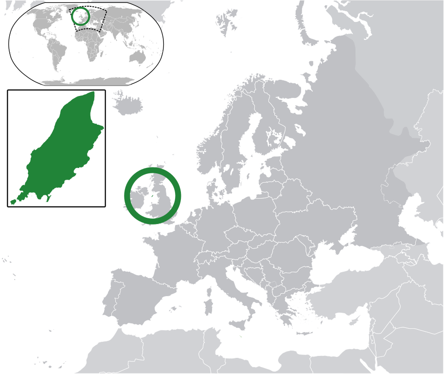
English:
Map in English of the Isle of Man, with bounds of sheadings, towns, villages, districts and parishes. (Green) Isle of Man.
(Gray) Europe.
(Light-gray) The surrounding region.
The Full Map of the Isle of Man |
||
| 日脚 | |||
| 来源 | 基于如下对象的个人作品: IsleOfMan SheadingsAndParishes-en.svg | ||
| 作者 | Chipmunkdavis | ||
| 许可协议 (重用本文件) |
本文件用知识共享“署名-相同方式共享 3.0 未本地化版本”许可协议授权。
|
||
| SVG开发 |
|
原始上传日志
This image is a derivative work of the following images:
- licensed with Cc-by-sa-3.0
- 2011-02-21T07:49:57Z Chipmunkdavis 2045x1720 (2394864 Bytes)
- IsleOfMan SheadingsAndParishes-en.svg licensed with Cc-by-sa-3.0,2.5,2.0,1.0, GFDL
- 2008-01-17T12:48:28Z Sémhur 1200x1100 (227618 Bytes) Update
- 2007-05-29T20:36:04Z Sémhur 0x0 (364350 Bytes) {{Information |Description=Map in English of the [[:en:Isle of Man|Isle of Man]], with bounds of sheadings, towns, villages, districts and parishes. |Source=Own work. Based on maps [[:Image:Isle of Man map-fr.svg]], [[:Image:
Uploaded with derivativeFX
文件历史
揿一个日脚/辰光来望当时出现过个文件。
| 日脚 / 辰光 | 微缩图 | 维度 | 用户 | 备注 | |
|---|---|---|---|---|---|
| 当前 | 2011年3月2号 (三) 14:10 | | 2,045 × 1,720(2.24 MB) | Chipmunkdavis | Redid inset |
| 2011年3月2号 (三) 14:03 |  | 2,045 × 1,720(2.22 MB) | Chipmunkdavis | Without inset | |
| 2011年3月2号 (三) 14:01 |  | 2,045 × 1,720(2.22 MB) | Chipmunkdavis | One more try | |
| 2011年2月21号 (一) 17:03 |  | 2,045 × 1,720(2.22 MB) | Chipmunkdavis | Grouped inset | |
| 2011年2月21号 (一) 17:00 |  | 2,045 × 1,720(2.22 MB) | Chipmunkdavis | File not appearing properly, reuploading | |
| 2011年2月21号 (一) 16:06 |  | 2,045 × 1,720(2.22 MB) | Chipmunkdavis | {{Information |Description={{en|1={{Europe-SVG-en|Northern Cyprus}}}} {{en|1=The Full Map of Jersey}} Map in english of the Isle of Man, with bounds of sheadings, towns, villages, districts and parishes. |Source=*[[:File:Europe-Jersey. |
文件用法
下向许1张用着箇文件:
全域文件用场
下底个其他wiki使用箇只文件:
- ace.wikipedia.org上个用途
- an.wikipedia.org上个用途
- ar.wikipedia.org上个用途
- arz.wikipedia.org上个用途
- ast.wikipedia.org上个用途
- az.wikipedia.org上个用途
- ba.wikipedia.org上个用途
- bg.wikipedia.org上个用途
- bh.wikipedia.org上个用途
- bn.wikipedia.org上个用途
- ca.wikipedia.org上个用途
- cdo.wikipedia.org上个用途
- cs.wikipedia.org上个用途
- diq.wikipedia.org上个用途
- en.wikipedia.org上个用途
- eo.wikipedia.org上个用途
- es.wikipedia.org上个用途
- ext.wikipedia.org上个用途
- fi.wiktionary.org上个用途
- fr.wikipedia.org上个用途
- ga.wikipedia.org上个用途
- gl.wikipedia.org上个用途
- hak.wikipedia.org上个用途
- ha.wikipedia.org上个用途
- he.wikipedia.org上个用途
- ia.wikipedia.org上个用途
- incubator.wikimedia.org上个用途
- it.wikipedia.org上个用途
- ja.wikipedia.org上个用途
- kab.wikipedia.org上个用途
- kk.wikipedia.org上个用途
- km.wikipedia.org上个用途
- la.wikipedia.org上个用途
- lb.wikipedia.org上个用途
- lij.wikipedia.org上个用途
- lv.wikipedia.org上个用途
- mk.wikipedia.org上个用途
查看本文件个更多全域用途。