跳转到内容

File:Carte topographique du Japon-fr.svg

页面内容不支持其他语言。
出自维基百科,自由个百科全书

原始文件 (SVG文件,名义大小:2,322×2,107像素,文件大小:3.91 MB)

箇文件维基共享资源里个,作兴会畀别个项目使用。渠个描述页里个说明显示如下。

小结

描述
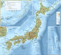
Français : Carte topographique et administrative en français du Japon
Deutsch: Topographische Karte / StraßenkarteJapans, in Französische.
English: Topographic and administrative map in French language of Japan.
Español: Mapa topográfico y administrativo en francès del Japón.
Italiano: Mappa topografica e amministrativa del Giappone (en francese).
日本語: 日本国の地図。
Português: Carta topográfica e da administração do Japão em francês.
  • Approximate geographic limits of the map (in meters, JGD CS IV meridian) :
    * N : 1425349
    * S : -667150.5
    * E : 1377700
    * W : -587303
  • Projection : JGD CS IV ; système géodésique WGS84
  • Shaded relief / relief ombré : image of N-W lightning position. L'ombrage du relief est une image bitmap embarquée dans le fichier SVG. / The shaded relief is a raster image embedded in the SVG file.
日脚 (UTC)
来源

Création personnelle ;

  • Topographie et bathymétrie : ETOPO1 de la National Geophysical Data Center ;
  • Coast, lakes, urban area, places, transportation, boundaries / Côtes, lacs, extension d'agglomération et villes, transports, frontières : NaturalEarth ; River / rivières : USGS HYDRO1k ;
作者 © Bourrichon (talk) - fr:Bourrichon
许可协议
(重用本文件)
Attribution and Share-Alike required
其他版本

Derivative works of this file:


Translate this file This SVG file contains embedded text that can be translated into your language, using any capable SVG editor, text editor or the SVG Translate tool. For more information see: About translating SVG files.
 
本W3C状态不明的矢量图使用Inkscape创作 .

授权协议

我,本作品著作权人,特此采用以下许可协议发表本作品:
w:zh:知识共享
署名 相同方式共享
本文件采用知识共享署名-相同方式共享 2.0 法国许可协议授权。
侬可以自由地:
  • 分享 – 复制、发行、展览、表演、放映、广播或通过信息网络传播本作品
  • 修改 – 改编本作品
来箇眼条件下底:
  • 署名 – 侬板定要畀出适当个署名,提供许可协议个链接,同时标明侬阿有改动过。侬好用任何合理个方式来做,但必过弗好用任何方式暗示许可人是侬或侬个使用背书。
  • 相同方式共享 – 如果你混合、转换或基于此素材创作,你板定要用搭原来相同或兼容个许可协议分发你个贡献作品。

说明

添加一行文字以描述该文件所表现的内容

此文件中描述的项目

描绘内容 简体中文

版权状态 简体中文

版权所有 简体中文

成立或创建时间 简体中文

11 7 2013

媒体类型 简体中文

image/svg+xml

校验和 简体中文

747b939f7b0a797be8210cf98579866da79a0360

断定方法 简体中文:​SHA-1

数据大小 简体中文

4,098,576 字节

高度 简体中文

2,107 像素

宽度 简体中文

2,322 像素

文件历史

揿一个日脚/辰光来望当时出现过个文件。

日脚 / 辰光微缩图维度用户备注
当前2017年3月26号 (日) 06:52于2017年3月26号 (日) 06:52个缩图版本2,322 × 2,107(3.91 MB)BourrichonCorrection des noms de quelques toponymes
2013年8月31号 (六) 01:45于2013年8月31号 (六) 01:45个缩图版本2,322 × 2,107(3.91 MB)Bourrichoncorrection mont Kōya et Kōfu
2013年7月12号 (五) 21:11于2013年7月12号 (五) 21:11个缩图版本2,322 × 2,107(3.91 MB)Bourrichondétails
2013年7月12号 (五) 03:39于2013年7月12号 (五) 03:39个缩图版本2,322 × 2,107(3.76 MB)Bourrichon-petite erreur (longue ligne noire tout en bas de l'image), +tri dans les calques
2013年7月12号 (五) 02:28于2013年7月12号 (五) 02:28个缩图版本2,322 × 2,112(3.78 MB)Bourrichon+coord
2013年7月12号 (五) 02:26于2013年7月12号 (五) 02:26个缩图版本2,322 × 2,112(3.76 MB)Bourrichon== {{int:filedesc}} == {{Information |Description= {{fr|Carte topographique et administrative en français du fr:Japon}} {{de|Topographische Karte / StraßenkarteJapans, in Französische.}} {{en|Topographic and administrative map ...

呒一页用着箇文件。

全域文件用场

下底个其他wiki使用箇只文件:

元数据