
File:COVID-19 Outbreak World Map.svg

原始文件 (SVG文件,名义大小:2,921×1,500像素,文件大小:1.72 MB)

|
该文件可能会更新以反映新信息 如果您希望在不镜像新更新的情况下使用该文件的特定版本,请将所需版本作为单独的文件上传。 |
小结
| 描述 |
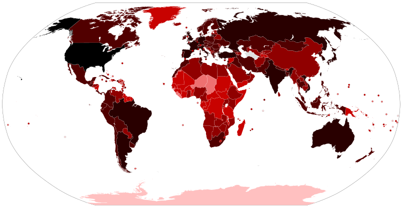
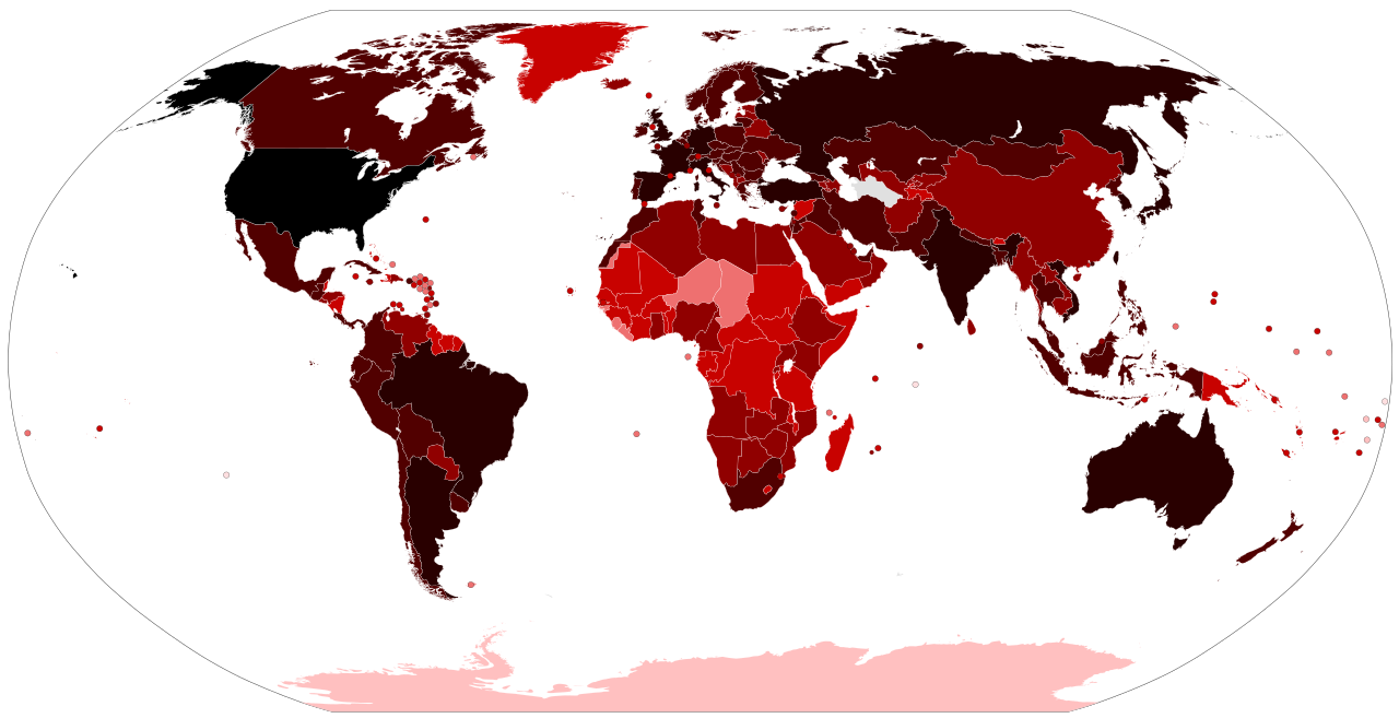
Map of the COVID-19 outbreak. Total cumulative confirmed COVID-19 cases by country. See the file history farther down for the latest upload date. Be aware that since this is a rapidly evolving situation, new cases may not be immediately represented visually. Refer to the primary article COVID-19 pandemic or the World Health Organization's situation reports for most recent reported case information. Legend information: 100,000,000+ Confirmed cases 10,000,000–99,999,999 Confirmed cases 1,000,000–9,999,999 Confirmed cases 100,000–999,999 Confirmed cases 10,000–99,999 Confirmed cases 1,000–9,999 Confirmed cases 100–999 Confirmed cases 1–99 Confirmed cases No confirmed cases, no population, or no data available |
| 日脚 |
– Date of first upload to the Wikimedia Commons. See the file history farther down for the latest upload date. Update the "point in time" date in the Wikidata entry linked below. {{wikidata|property|Q101240885|P585}} is used in map captions on Wikipedia. It provides the map date. To enable the date change click the purge link after updating the Wikidata entry. |
| 来源 |
Latest versions: https://ourworldindata.org/explorers/coronavirus-data-explorer?tab=map&Metric=Confirmed+cases&Interval=Cumulative&Relative+to+Population=false&Align+outbreaks=false&country=~OWID_WRL - Our World in Data. Click on the download tab to download map. The table tab has a table of the exact data by country. Source tab says data is from the COVID-19 Data Repository by the Center for Systems Science and Engineering (CSSE) at Johns Hopkins University. The map at the source is interactive and provides much more detail. For example, run your cursor over the color bar legend to see the countries that apply to that point in the legend. |
| 作者 |
Various Commons editors. See file history for latest ones. Older versions: Svenskbygderna (original author); Ratherous, AKS471883 (contributors); authors of File:BlankMap-World.svg (source file) |
| 其他版本 |
|
| SVG开发 |


授权协议
文件历史
揿一个日脚/辰光来望当时出现过个文件。
| 日脚 / 辰光 | 微缩图 | 维度 | 用户 | 备注 | |
|---|---|---|---|---|---|
| 当前 | 2023年6月14号 (三) 22:21 | | 2,921 × 1,500(1.72 MB) | AKS471883 | Macao 10000 |
| 2023年2月26号 (日) 00:55 |  | 2,921 × 1,500(1.72 MB) | AKS471883 | Taiwan 10000000 | |
| 2023年1月17号 (两) 10:10 |  | 2,921 × 1,500(1.72 MB) | AKS471883 | Argentina 10000000 Channel Islands 100000 | |
| 2022年12月24号 (六) 13:56 |  | 2,921 × 1,500(1.72 MB) | AKS471883 | Tokelau 5 | |
| 2022年12月20号 (两) 11:26 |  | 2,921 × 1,500(1.72 MB) | AKS471883 | Uruguay 1000000 | |
| 2022年12月16号 (五) 11:02 |  | 2,921 × 1,500(1.72 MB) | AKS471883 | Mongolia 1000000 | |
| 2022年12月14号 (三) 19:07 |  | 2,921 × 1,500(1.72 MB) | AKS471883 | Macao 1000 | |
| 2022年12月4号 (日) 13:50 |  | 2,921 × 1,500(1.72 MB) | AKS471883 | Panama 1000000 | |
| 2022年11月24号 (四) 11:09 |  | 2,921 × 1,500(1.72 MB) | AKS471883 | GUAM | |
| 2022年11月23号 (三) 00:47 |  | 2,921 × 1,500(1.72 MB) | S17003 | USA 100000000 |
文件用法
下向许1张用着箇文件:
全域文件用场
下底个其他wiki使用箇只文件:
- af.wikipedia.org上个用途
- als.wikipedia.org上个用途
- ar.wikipedia.org上个用途
- ar.wikinews.org上个用途
- ast.wikipedia.org上个用途
- az.wikipedia.org上个用途
- be.wikipedia.org上个用途
- bh.wikipedia.org上个用途
- bn.wikipedia.org上个用途
- bs.wikipedia.org上个用途
- ca.wikipedia.org上个用途
- cs.wikipedia.org上个用途
- da.wikipedia.org上个用途
- de.wikipedia.org上个用途
- de.wikinews.org上个用途
- el.wikipedia.org上个用途
- en.wikipedia.org上个用途
- User:LightandDark2000
- User:JeremyNguyenGCI/sandbox
- Wikipedia:Top 25 Report/January 19 to 25, 2020
- COVID-19 pandemic by country and territory
- Talk:COVID-19 pandemic by country and territory/Archive 1
- Wikipedia:Top 25 Report/January 26 to February 1, 2020
- Wikipedia talk:WikiProject Medicine/Archive 132
- Wikipedia:Top 25 Report/February 2 to 8, 2020
- Wikipedia:Top 25 Report/February 9 to 15, 2020
- Wikipedia:Top 25 Report/February 16 to 22, 2020
- Wikipedia:Wikipedia Signpost/2020-03-01/Traffic report
- Wikipedia:Top 25 Report/February 23 to 29, 2020
- Wikipedia:Wikipedia Signpost/Single/2020-03-01
- Wikipedia:Top 25 Report/March 1 to 7, 2020
- Wikipedia:Top 25 Report/March 8 to 14, 2020
- Wikipedia talk:In the news/Archive 74
- Template talk:COVID-19 pandemic/Archive 1
查看本文件个更多全域用途。