
File:2006 North Korean nuclear test.svg

此SVG文件的PNG预览的大小:473×408像素。 其他分辨率:278×240像素 | 557×480像素 | 890×768像素 | 1,187×1,024像素 | 2,374×2,048像素。
原始文件 (SVG文件,名义大小:473×408像素,文件大小:71 KB)
小结
| 描述 |
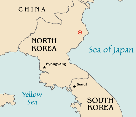
Map of the North Korean nuclear test of October 9, 2006. The red marker indicates the estimated location of the test (41.311°N, 129.114°E). Based off of maps from the CIA World Factbook. |
| 日脚 | 2006年10月10日 (原始上传日期) |
| 来源 | No machine-readable source provided. Own work assumed (based on copyright claims). |
| 作者 | No machine-readable author provided. Mobius assumed (based on copyright claims). |
| 其他版本 |
|


授权协议
| 我,本作品著作权人,释出本作品至公有领域。这适用于全世界。 在一些国家这可能不合法;如果是这样的话,那么: 我无条件地授予任何人以任何目的使用本作品的权利,除非这些条件是法律规定所必需的。 |
文件历史
揿一个日脚/辰光来望当时出现过个文件。
| 日脚 / 辰光 | 微缩图 | 维度 | 用户 | 备注 | |
|---|---|---|---|---|---|
| 当前 | 2006年10月11号 (三) 04:48 | | 473 × 408(71 KB) | Mobius | + Crop area, proper license |
| 2006年10月11号 (三) 04:43 |  | 981 × 801(71 KB) | Mobius | Map of the North Korean nuclear test of October 9, 2006. The red marker indicates the estimated location of the test (41.311°N, 129.114°E). Based off of maps from the CIA World Factbook. |
文件用法
呒一页用着箇文件。
全域文件用场
下底个其他wiki使用箇只文件:
- ca.wikipedia.org上个用途
- en.wikipedia.org上个用途
- ia.wikipedia.org上个用途
- ko.wikipedia.org上个用途
- nl.wikipedia.org上个用途
- no.wikipedia.org上个用途
- pl.wikinews.org上个用途
- ta.wikinews.org上个用途
- www.wikidata.org上个用途